
Contents
The imperative for robust Master Data Management (MDM) has never been more critical, particularly in today’s environment where data is no longer static—it is dynamic, expansive, and increasingly geospatial.
Picture a utility company struggling to pinpoint the exact location of a power outage affecting thousands of customers, only to realize their master data is scattered across multiple systems. Nothing less than a nightmare. Organizations are evolving beyond traditional ERP and CRM systems, seeking solutions capable of managing the growing volume and complexity of data. If you find yourself asking, “What is Master Data Management?” this article will delve into the transformative potential of ArcGIS as a foundational element of MDM, demonstrating how it revolutionizes the way organizations manage their master data and fosters seamless, cross-departmental collaboration.
What is Master Data Management?
Master Data Management (MDM) can be best understood as the central nervous system of an organization’s data infrastructure. It serves as the foundational framework that ensures data is consistent, accurate, and accessible across the entire enterprise. By acting as the brain of an organization’s data ecosystem, MDM plays a pivotal role in streamlining operations, enhancing decision-making processes, and ensuring compliance with industry regulations. It achieves this by consolidating, organizing, and maintaining critical data entities—such as customer information, product details, supplier records, and location data—into a single, unified, and authoritative source. This centralized approach eliminates data silos, reduces redundancies, and ensures that every department operates with the same reliable and up-to-date information. In doing so, MDM not only improves operational efficiency but also fosters cross-departmental collaboration, enabling organizations to deliver better customer experiences, optimize supply chains, and make data-driven decisions with confidence.
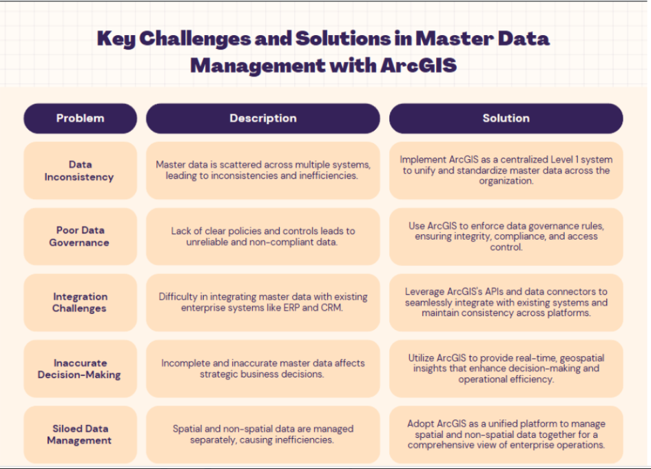
ArcGIS as a Level 1 System for MDM
Historically, geographic and spatial data were often confined to isolated silos, detached from the broader enterprise ecosystem. However, the integration of Geographic Information Systems (GIS) with core enterprise applications has catalyzed a significant transformation in how organizations approach Master Data Management (MDM). ArcGIS, developed by Esri, represents a leading GIS platform that enables organizations to effectively manage both spatial and non-spatial data within a single, cohesive framework. By assuming the role of the Level 1 system for MDM, GIS services enhance decision-making, ensure accurate reporting, and optimize operational efficiency critical factors for modern, data-driven enterprises.
Benefits of Integrating ArcGIS with Enterprise MDM
- Data Consistency & Accuracy: ArcGIS ensures consistent spatial data across the organization, reducing discrepancies and enhancing reliability
- Improved Decision-Making: Provides a unified view of spatial and non-spatial data, enabling more informed decisions
- Operational Efficiency: Streamlines workflows, reduces redundancy, and optimizes resource allocation with accurate spatial data
- Data Ownership: Clarifies data ownership, ensuring accountability for updates and maintenance
- Data Validation & Cleansing: ArcGIS solutions automate data validation and error detection, such as geographic inaccuracies in utility infrastructure
- Industry-Specific Applications: ArcGIS ensures spatial data accuracy in sectors like utilities, improving master data quality and decision-making
Integration with Existing Systems
Master Data Management (MDM) is crucial for businesses aiming to maintain accurate and reliable information across their systems. The ArcGIS Utility Network enhances this by integrating seamlessly with MDM systems, allowing utilities to manage and visualize spatial data alongside essential business data. This integration serves as a central hub where data from various sources is collated, standardized, and then shared across departments. ArcGIS can be integrated with ERPs, CRMs, and other enterprise solutions through advanced APIs and data connectors.
Furthermore, ArcGIS facilitates collaborative workflows, allowing different departments to access and update master data based on their specific roles. By leveraging cloud-based platforms such as ArcGIS Online and other ArcGIS SaaS offerings, organizations can establish shared environments where teams can work together on mapping and analyzing spatial data. This promotes cross-departmental collaboration and ensures that all team members are using the most up-to-date information.
In addition, ArcGIS Enterprise and Enterprise Geodatabases offer robust solutions for managing large volumes of spatial data within an organization’s infrastructure. These tools provide advanced capabilities for data storage, management, and analysis, ensuring seamless integration and accessibility of critical business and spatial data across the enterprise.
By integrating cloud-based and on-premises solutions, organizations can fully harness the power of ArcGIS to enhance their data management and collaborative efforts.
CyberTech: Your Partner in GIS Expertise
When it comes to implementing and optimizing Geographic Information Systems (GIS) for Master Data Management, CyberTech stands out as a trusted expert. CyberTech is proud to be the first partner recognized for cloud speciality, second only to Esri. With years of experience in delivering cutting-edge GIS solutions, CyberTech has helped numerous organizations harness the full potential of ArcGIS to streamline their data management processes. From data migration and integration to custom application development and training, CyberTech offers end-to-end services that ensure seamless adoption and maximum ROI. Whether you’re looking to centralize spatial data, enhance decision-making, or improve operational efficiency, CyberTech’s deep expertise in GIS makes them the ideal partner for your enterprise’s MDM needs.